


Lake St. Francois-Xavier
Lake Saint-François-Xavier is a lake in the Laurentians located in the village of Montfort, in the municipality of Wentworth-North. One travels approximately 80 km to get there from Montreal, by the Laurentian highway, then road 364 and finally the Chemin de Montfort.
Kingfisher trill
The sawmill duct
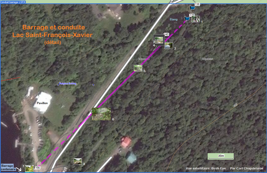


Lake St. François-Xavier's dam
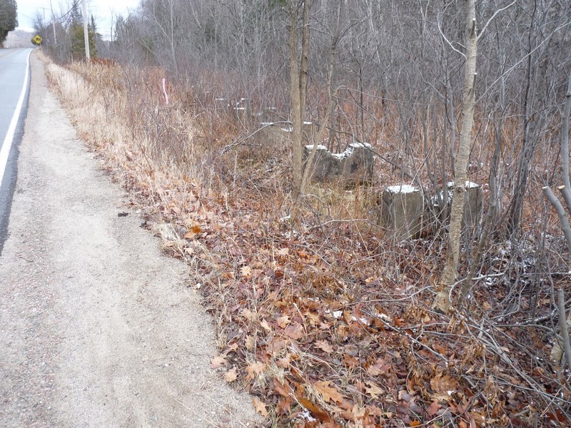
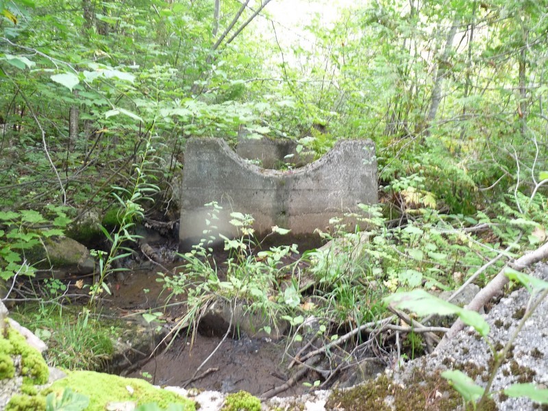
In its 1941 report, the Commission of Common Waters of Quebec mentions the existence of two concrete dam sections, a first one of 29 feet. (It was at the entrance of the road access leading to the Montfort Pavilion, where the observation trench has just been dug and where is the fire water intake; but where you will not see much visible traces of still present concrete parts. According to the report, the dam had a hole to let the water pass to a wooden supply line (girdled with iron); its diameter is not specified.
(Our hypothesis is that the original duct was at least of four feet in diameter. The dam was demolished and replaced by the current dike. A huge funnel, possibly in metal, would eventually be incorporated into the structure to direct water towards the duct, while the wooden one was replaced by a metallic, of only two feet in diameter The latter proved to be insufficient to supply the saw mill and the power plant situated below, without forgetting, at a time, the wooden pool for the orphans. A large diesel Chrysler engine had to be added, as well as a huge reservoir for this hydrocarbon that has had the misfortune to flow into Deer Lake to kill quantity of fish.)
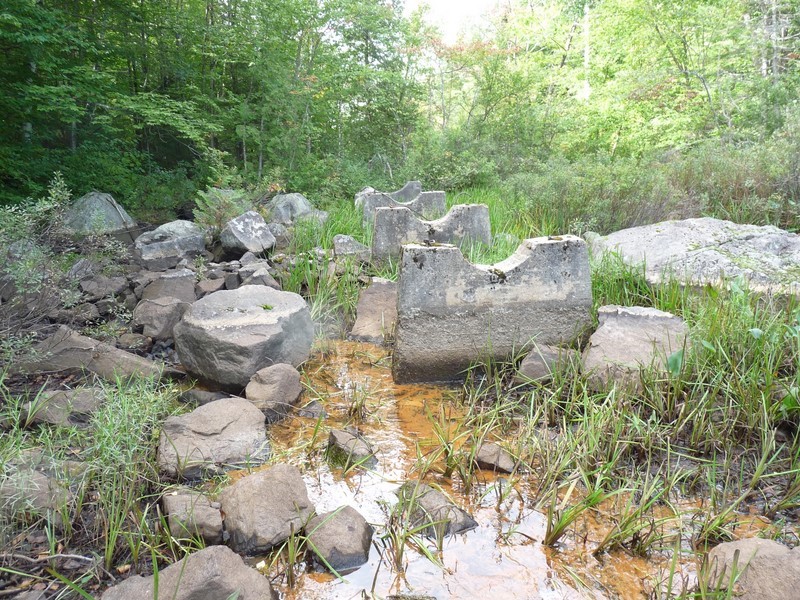
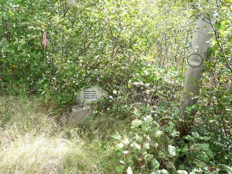
This duct appears to have been in a straight line, from the opening in the dam to the last concrete pillar. It borrowed a depression in the land while leaving the dam, at the crossing of route Principale and the access road to the Pavilion, where it passed under a bridge. A long series of these supporting pillars, spaced by ten feet, are always present at the entrance of the village and join the Main road at Hydro Quebec’s post 14-42. But they are almost completely hidden by shrub lands. Strangely enough, these pillars are sometimes of arch opening for receiving an about two feet in diameter duct, while others, interspersed in the alignment, are rather designed to receive one of at least four feet; i.e. probably for the earlier wooden conduct but as well used to support the new one.
The second section of concrete was a 70-foot dam (probably the one blocking the current channel that opens next to the Pavilion), pierced with two openings for overflow, a bottom valve and a wooden sluice 8 feet wide (Is it a door that can be used to remove water during floods?). It was probably the section that was demolished to be replaced by culverts under the Chemin de Lisbourg and on which the boys liked to show fearlessness.
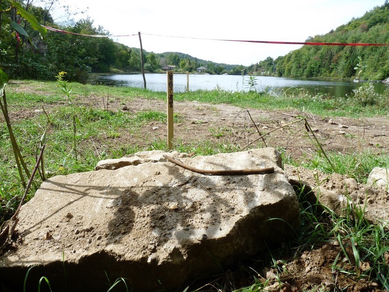
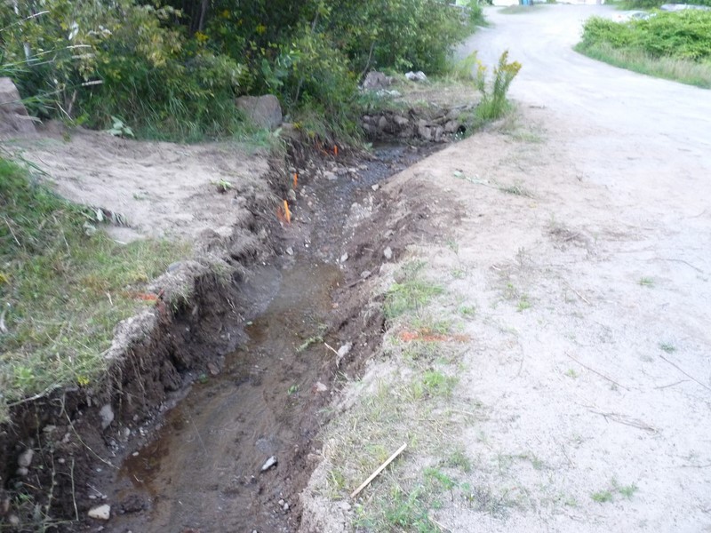
As we were told by Mr. Mayor Genest, water leaks appeared in downstream of the structure in recent years. On dry weather indeed, several small water leaks are now visible in the observation trench dug for this purpose. The MRC has recently hired Mr. Pierre Dumas, an engineer and consultant in hydraulics, energy and environment, expert in dammed lakes, to conduct a safety study on the century-old dam. We saw the engineer at work on earth and, using a tuba, in the lake, not far from where the fire water intake is located.
No tree planting should have dressed this structure had already learned Mayor Genest; with decomposition, tree roots, which have drilled deep paths, will eventually leave as many inappropriate channels to pressurized water. He had also let know that an engineering firm, briefly consulted, was already suggesting a widening of the dam where are the seen leaks, while a second, specialized in dams, would have gone for digging there a trench to be filled with clay.
The rupture of a lake or river dam may occur, as was the case with the artificial Lake Bison (600 meters long) at Saint-Raymond, in Portneuf, which emptied in about five minutes in June, after having yet undergone the prescribed inspections successfully. Some local residents reported having experience a mini tsunami and believe that water infiltration in the dam could be the cause, while heavy rainfalls had completed the work. The unlikely failure of the dam of Lake Saint-François-Xavier would be of a different order of magnitude; mais dont le Québec a eu de tristes exemples. but Quebec has known sad examples of such.
A first dam and duct were therefore built at Lake St. François-Xavier from the beginning of colonization; it was essential to the operation of a sawmill that would allow the construction of the village and the orphanage. That probably was the dam that would have collapsed, as reported by the elders, taking away all the facilities of the mill it served at the time; mais apparemment sans faire de victime. but apparently causing no casualties.
Thank you to Mr. Gérard Chartier for his valuable collaboration.
Information and old photos from residents to shed light on the overall picture of this issue would be most appreciated.
* http://www.cehq.gouv.qc.ca/barrages/detail.asp?no_mef_lieu=X0005087
Carl Chapdelaine
observation trench
Former Lake (West)
Former Lake (East)
Oh Lake!
With the best wishes for the Christmas Holidays from the RSVL team.
Lake
Alphonse Beauregard (1881-1924)
At the feet of three hills dressed with firs lies a deep, clear and wise lake, where many times I got off, in the morning, to pick up the peace it offers.
Round and lush, at its centre, an island looks like the diamond of a ring. Around, leaning trees, at the water's edge, draw there vague shapes.
Still free of any dock, of any open path; useless and pure tiara; it is in the harshness of this desert country, a work of art to the art itself.
I'm your poor lover, Lake; but can't stop sinister axes. Hear their sound around, the bell tools of the trees which dress-up and hide you.
You will become, among houses and bare fields, water without attractions, a pool, a thing which is used to navigate over, grabbed by masses.
Who cares! They will not, these imposed masters, have known your smile of virgin; I keep it in my heart like a secret kiss that I would have picked on your bank.
satellite Image
Lake St. Francois Xavier

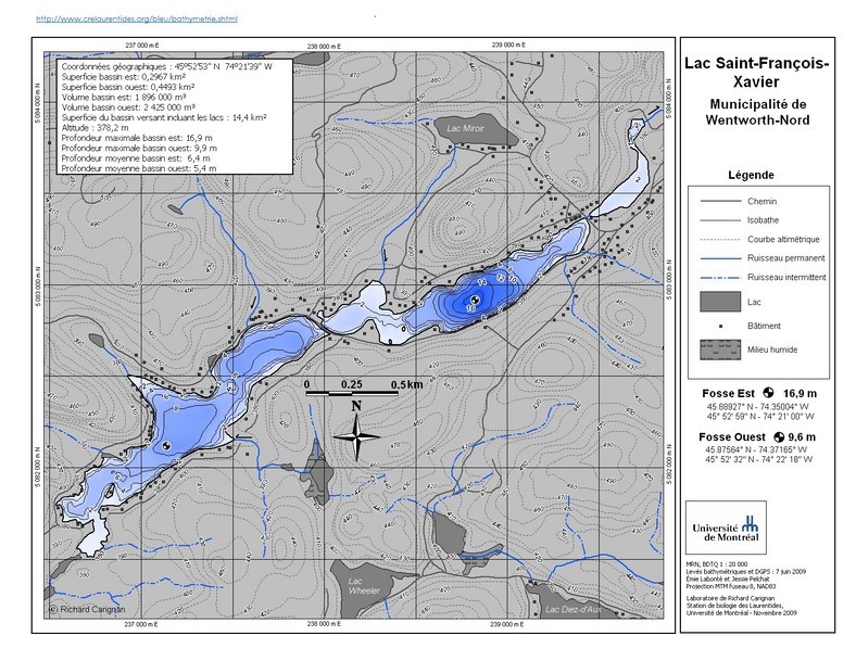
Topographic map of the lake
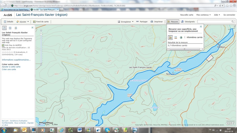
«Toporama» is a service of the Atlas of Canada. The arrow turns into cross to go in all directions, covering all of Canada. The search tool takes you directly to the desired location (but you will have to find your way back…).
The map can be enlarged to full page using the link at the bottom, to the left of the latter; you then discover new interesting strong tools. One of them allows you to measure the distance between two points that you have placed anywhere on the map, or to get the area of a polygon that you have managed to draw around a lake, for example.
Click on the small image, here on the right, to see how I got 0.7 square km for Lake Saint-François-Xavier, by drawing its outline, in fact, by a succession of straight segments forming the sought polygon (blue line).
As a first step, once the map is zoomed in, you "put under the magnifying glass" i.e. maximize what you want to measure; it will be more accurate. You click on "To measure". The icon of the tool for measuring a surface appears darker; then you point the arrow on your starting point and click left once. You move the line to the first change in direction, then release. You click left once again; and so on until you have closed the polygon. You then double-click, always left, and look at the result. Don't worry about the other side of the polygon that follows your every movement. But don't do anything else at the same time; you could ruin your effort...
If you find more interesting options, let us know.
Lake St. Francois Xavier watershed
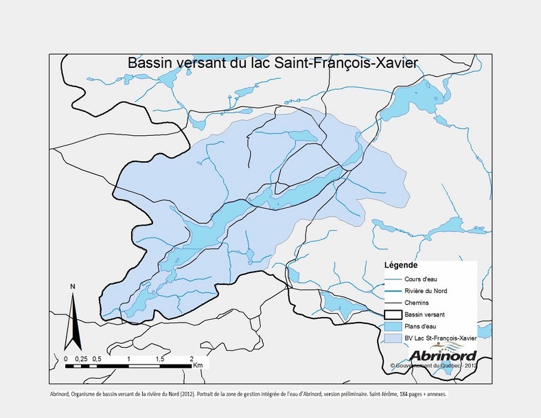
A first publication of such a map, thanks to Abrinord.
Lake Saint-François-Xavier watershed is a sub-basin of the Rivière-à-Simon’s one. This watershed is itself included in the Rivière du Nord watershed, which with that of the Rivière Rouge cover a large part of our region before both flowing into the Ottawa River. The bold black line on this map delineates this whole from the Rivière rouge watershed, at West and South here, with Notre-Dame and Saint-Victor Lakes left blank. Our thanks to Abrinord, the Rivière du Nord watershed organization, involved in several research projects carried out by the MRC or other and with which we look forward to collaboration in certain issues.
Rivière-à-Simon's watershed
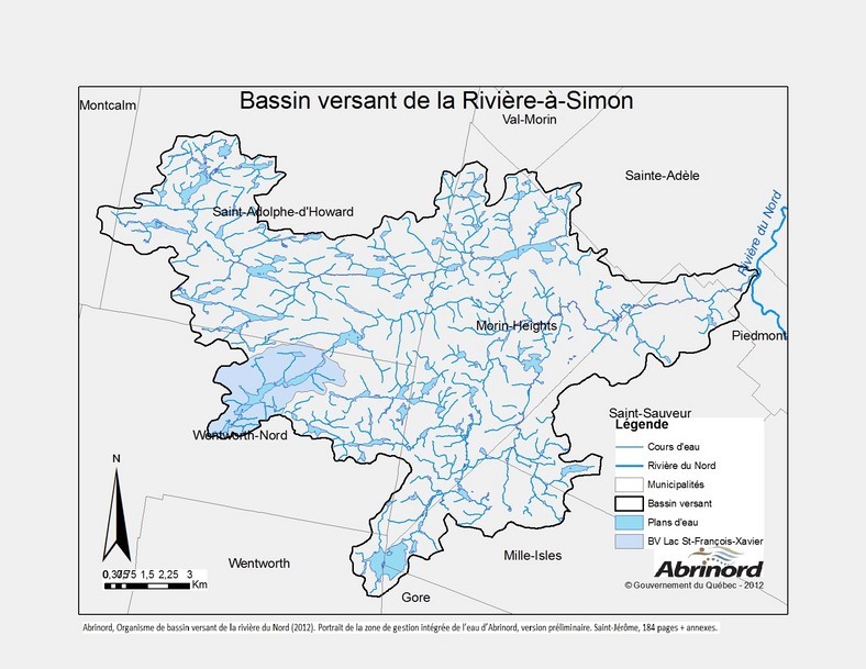
Here, at a smaller scale, is the Rivière-à-Simon watershed in which are included Lake St. François-Xavier and Deer Lake.
You will find our lake at the southwestern end, just over the word Wentworth-Nord, since the limit separating us from Rivière Rouge watershed goes between our lake and the Lake St. Victor - Lake Notre-Dame duo.
You will notice that we are at the head of our part of the watershed, only topped by small Lac-à-la-Croix. We may be a risk for others, namely Lake Chevreuil, but no one is a risk to us.
Now, isn’t that amazing to see the area covered by the Rivière-à-Simon watershed?
Navigation bylaws
